M6 - Georeferencing
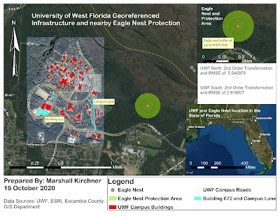
University of West Florida Georeferenced Infrastructure and nearby Eagle Nest Protection Three Dimensional Map Showcasing the University of West Florida Campus The final laboratory assignment of this course was informative, exciting, and all-encompassing. I was able to apply concepts learned from previous labs while continuing to expand upon my GIS knowledge. This assignment resulted in the creation of two separate maps, one being of the final georeferenced image of UWF's Campus (and an inset map of the eagle nest), and the other being a 3D map of UWF's campus. I was able to use georeferencing to overlay pictures to create the UWF campus map and Heritage Hall's planning image. This was a skill that I greatly enjoy utilizing, as I find it very pleasing watching images align after placing control points. I used the editing tab to add a building (079) and road (Campus Lane) to be used in both the final campus and 3D map. For the 3D map, I was able to learn how Lidar imagery ...