Posts

Showing posts from October, 2020

M1 - Visual Interpretation

Image
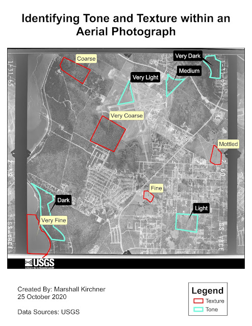
  Aerial Image Tone and Texture Identification For the first part of this laboratory assignment, I identified and labeled areas of an aerial image. This involved the utilization of editing skills previously learned in the GIS program at UWF. I enjoy practicing my polygon creation techniques, and found the process as a whole to go by quicker with time. I created two separate feature classes that would include shapefiles of both textures and tones to hold the created polygons. I then used the calculate tool for the attribute tables of each to create names for the resulting tones and textures. I enjoyed using the labeling tool to label these polygons based on their names, and editing the symbology so that the labels would be easy to read and identify. I struggled at first with having the labels cover the areas in which they were representing, but I found that in the labeling tab, one is able to position them so that they lay on the outside of the created polygons. Ultimately, I really enj

M6 - Georeferencing

Image
  University of West Florida Georeferenced Infrastructure and nearby Eagle Nest Protection Three Dimensional Map Showcasing the University of West Florida Campus The final laboratory assignment of this course was informative, exciting, and all-encompassing. I was able to apply concepts learned from previous labs while continuing to expand upon my GIS knowledge. This assignment resulted in the creation of two separate maps, one being of the final georeferenced image of UWF's Campus (and an inset map of the eagle nest), and the other being a 3D map of UWF's campus. I was able to use georeferencing to overlay pictures to create the UWF campus map and Heritage Hall's planning image. This was a skill that I greatly enjoy utilizing, as I find it very pleasing watching images align after placing control points. I used the editing tab to add a building (079) and road (Campus Lane) to be used in both the final campus and 3D map. For the 3D map, I was able to learn how Lidar imagery

M5 - Add XY and Geocoding

 Link to web map http://arcg.is/1yjyuv0 This two part lab was very informative, interdisciplinary, and engaging. I learned a multitude of new GIS concepts throughout this lab that will certainly be applicable to my future coursework and career. Starting out with creating and manipulating data in the excel spreadsheet allowed me to understand how the data should look for implementation into ArcGIS Pro and was good practice in brushing up on my Excel skills. After doing so and importing the data into the map, I was able to use an address locater and geocode to produce a basic map of all of the schools within Brevard County, Florida. The usage of the different tools and skills that were utilized in this lab were all very exciting and fun to work with. What I had trouble most with was exporting my map to a web map version, which I have learned the basics of through much troubleshooting. Essentially, the basemap and the layers I had created were of two different projections and I simply had